Tropical Cyclone 18S IDAI (Africa)
Information as of 27 March 2019 – Report No. 1
Authors: Bernhard Mühr, Sanna Mohr
1. Overview
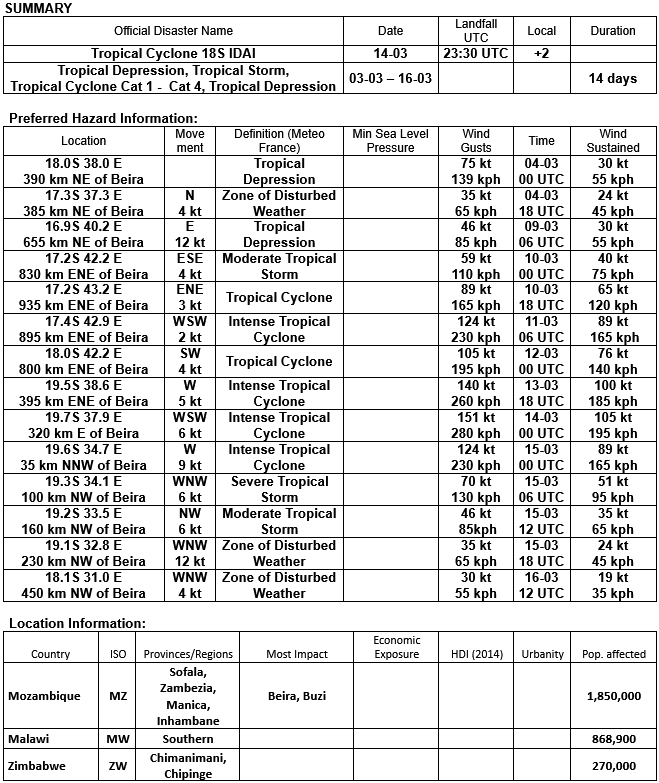
Over a period of 2 weeks, the long living tropical system IDAI hit large parts of South East Africa. At the beginning it was only the precursors of the tropical cyclone that caused major flooding in Malawi. Some days later, over the warm waters of the Mozambique Channel the system went through all stages of development and finally became a full-grown tropical cyclone with sustained winds of 195 kph and gusts of 280 kph. Shortly after peak intensity, IDAI fell ashore in Mozambique a few kilometres north of the city of Beira in the night from 14 to 15 March 2019.
A slow propagation speed, a destructive storm surge, heavy winds and enormous precipitation led to extensive damage and flooding. And even the remnants of the dying tropical system caused further floods and landslides far inland in the east of Zimbabwe.
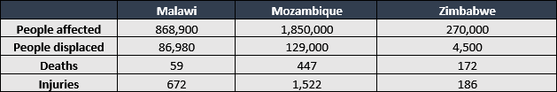
A total of around 3 million people were affected by IDAI and its impacts. IDAI claimed several hundred lives and left hundreds of thousands of people homeless and displaced across the region. For Mozambique, IDAI could even become the most devastating and deadliest tropical cyclone in history.
2. Meteorological Information
2.1 Preliminary Remarks
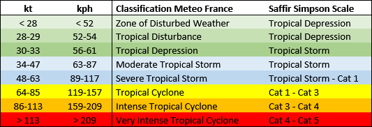
With respect to tropical cyclones, Meteo France is responsible for the southwest Indian Ocean area. In this region a particular classification for tropical weather systems is in use. The classification system, its thresholds and terms differ from the more known Saffir-Simpson Hurricane Scale, which is applied for the Atlantic and Eastern Pacific storm basins (Table 1).
Table 1: The classification of tropical weather system in the southwest Indian Ocean and the corresponding terms of the Saffir-Simpson Hurricane Scale.
2.2 Evolution of Tropical Cyclone IDAI
IDAI was the seventh intense tropical cyclone of the Indian Ocean basin’s 2018-2019 season.
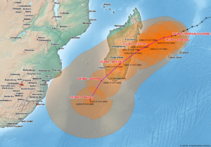
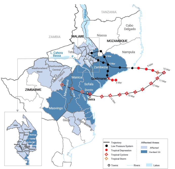
The beginnings of IDAI can traced back until 3 March 2019 where it was born just off Mozambique’s coast over the warm waters of the Mozambique Channel. The Mozambique Channel is part of the Indian Ocean and stretches as an 400 km wide arm between the coast of Mozambique and the island of Madagscar. IDAI first developed as a tropical disturbance and increased into a tropical depression until 4 March 2019. The following days IDAI made a loop crossing the far south eastern tip of Malawi and finally turned into a easterly to south easterly direction. While looping inland, heavy rain occurred already across parts of Mozambique and souther Malawi resulting in desastrous flooding.
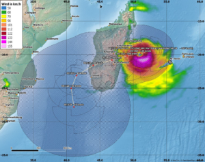
After a slight decrease IDAI entered the Mozambique Channel on 9 March 2019. Very warm surface water temperatures and the absence of strong winds in the upper troposphere created favourable conditions for a rapid development. On 10 March 2019, 18 UTC, IDAI reached its easternmost point of its track, just 100 km west of the coast of Madagascar. The following day after a sharp U-turn, IDAI was a Category 3 tropical cyclone between 03 and 06 UTC with respect to the Saffir-Simpson hurricane scale. Maximum wave heights were 8 meters. Until 12 March 2019, 03 UTC, IDAI weakened into a Category 2 storm but developed a well defined eye. Wile maintaining Category 2-3 strength, cloud top temperatures were at -57C. IDAI’s eye was 37 km in diameter although covered by high clouds.
On 14 March 2019, 00 UTC, IDAI reached maximum intensity with 10-minute sustained winds of 105 kt (195 kph) and gusts of 151 kt (280 kph). Landfall was on 14 March 2019, 23:30 UTC, few kilometers north of the city of Beira in Mozambique, sustained winds were 95 kt (177 kph) making IDAI an upper Category 2 tropical cyclone at that time.
While slowly travelling overland into a westerly direction it took 2-3 more days for IDAI to dissolve. During that time the remnants of the cyclone caused heavy rains, riverine and flash flooding all the was into eastern Zimbabwe.
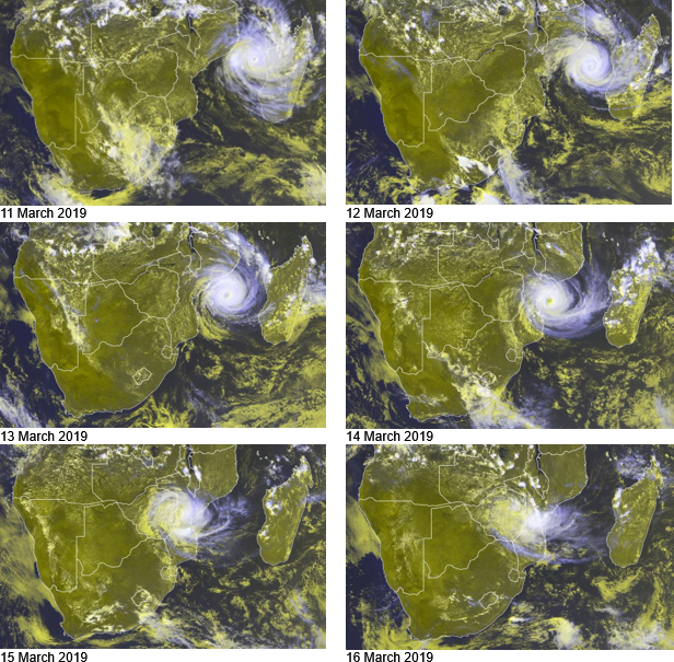
The series of satellite images covering the period from 11 to 16 March 2019 (Figure 2) shows how IDAI gained strength when reaching the warm waters of the Mozambique Channel. With an undisturbed circulation over open waters IDAI formed a well pronounced eye. After an U-turn IDAI headed for Mozambique where the tropical cyclone finally made landfall late on 14 March 2019 near the city of Beira. While slowly moving inland IDAI quickly lost intensiy, however, was responsible for enormous rain amounts for two more days even in eastern Zimbabwe, 500 km west of the coastline.
2.3 Precipitation
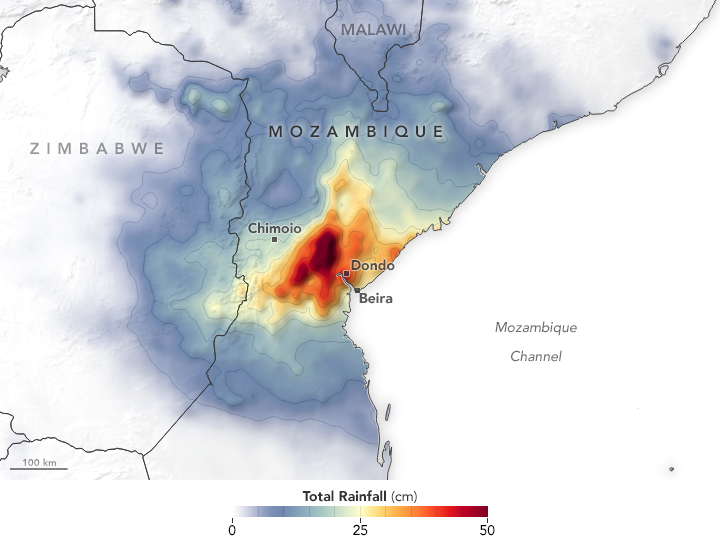
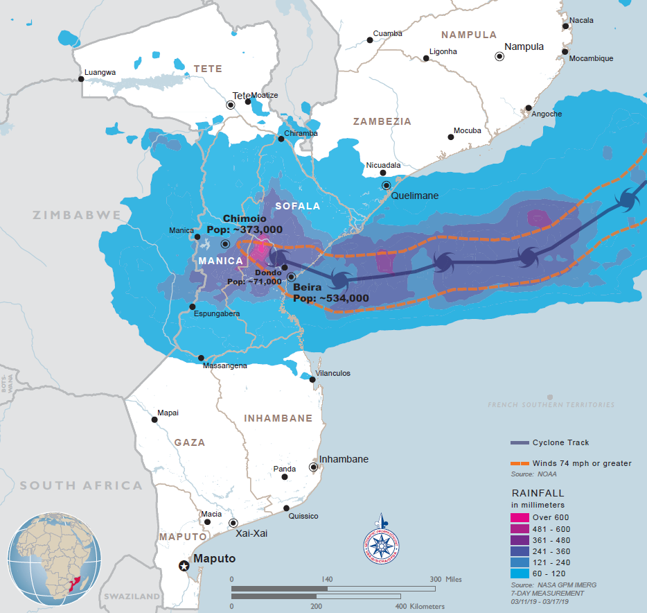
IDAI dropped enormous amount of rain along its path. Due to its large extent and low propagation speed at landfall the tropical cyclone was responsible for rain accumulation in excess of 500 mm in many regions of central Mozambique (Figure 3), in the Sofala province even more than 600 mm have been calculated (Figure 4). There are no direct measurements and these estimates are based on satellite data that come from the Integrated Multi-Satellite Retrievals (IMERG) which is a product of the Gobal Precipitation Measurement mission (GPM). Locally, rain amounts may have been even higher. Intense rainfall did also occur in the eastern parts of Zimbabwe, where the dissipating cyclone brought rain amounts of well above 200 mm.

3. Impacts
Tropical cyclones can cause serious damage in many ways:
- The effect of persistent high average wind speeds and gusts on buildings and other facilities (such as trees, electricity pylons, agricultural crops, etc.), especially on islands and along coastal shores.
- By the storm surge, generated by a hurricane already before its arrival in coastal areas, bays and larger estuaries and deltas. In particularly shallow coastal areas can be submerged.
- Intense rainfall that causes flooding of rivers and their floodplains. In mountainous terrain, landslides often occur.
Although the intensity of tropical cyclones is based almost entirely on wind speeds, even tropical storms or weaker systems corresponding to category 1 or 2 can sometimes cause more damage than the worst tropoical cyclones. The destructive wind speeds usually only occur in relatively narrow areas around the center of the cyclone and also decrease rapidly inland. The flooding caused by storm surges and large-scale heavy rainfall has a much greater potential for damage.
The silmultaneous occurrence of a storm surge and a spring tide can particularly damage coastal areas. The weather conditions during the weeks before landfall, especially the previous rainfall and soil moisture conditions, also play a role as well as the terrain configuration. The coastal shape and estuaries can further increase a rising storm surge. On mountain slopes, landslides can occur.
And last but not least, the propagation speed of the tropical systems is of crucial importance if quasi-stationarity causes enormous rainfall for days.
3.1 Impacts of tropical cyclone IDAI
Table 2: Key figures for affected countries as of 26 March 2019. Data Source: reliefweb.int
3.2 Storm surge
IDAI made landfall on 14 March 2019 at around 23:30 UTC which coincided with hith tide. Both the storm surge and the high tide led to a worst case scenario with IDAI pushing a wall of water inland. The storm surge was estimated as high as 6 metres in some places and caused large floodings in low lying areas along the Pungwe river.
3.3 Large-scale flooding due to heavy rain
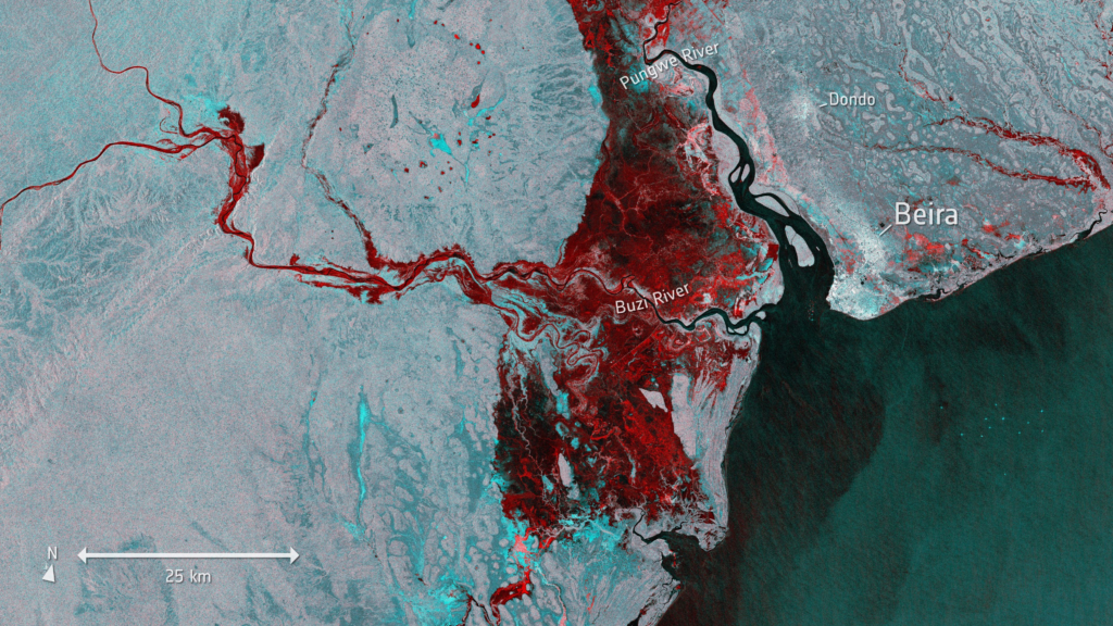
Water proved to be the most destructive element. The storm surge and subsequent excessive amounts of rain led to an inland lake. Entire communities and villages disappeared under water. Based on Sentinel-1 data from 19 March 2019 water covered an area of 2,165 km². In some places the water surface was as wide as 45 km.
3.4 Damages and Consequences
As a developing region with relatively poor disaster warning, preparedness and coping strategies, countries such as Madagascar and Mozambique are in some respects more vulnerable to tropical cyclone disasters than regions with robust disaster risk reduction and coping strategy initiative (Fitchett and Grab, 2014).
A total of nearly 3 Million people have been affected by tropical cyclone IDAI. Even the precursors of IDAI caused widespread flooding in southern Malawi and was responsible for at least 50 deaths. After landfall IDAI ravaged through the central parts of Mozambique, namely the provinces of Sofala, Zambezia, Manica and Inhambane. In the coastal town of Beira, which is the Mozambique’s 4th largest city with a total population of 538,000 and equipped with an important harbor and an international airport, most of the area was completely destroyed.
The remnants of IDAI affected at least half of the total population of eastern Zimbabwe’s Chimanimani and Chipinge districts. At least 16,000 households need shelter assistance in Chimanimani, Mutare, Chipinge and Buhera, according to the government.
- Many roads destroyed, main access bridges washed away.
- The water and energy supply and telecommunication and other services interrupted.
- Significant damage to educational and health facilities.
- Hundreds of thousands of hectares of crops have been flooded, causing severe problems for the food supply for the months ahead, especially because the losses coincide with the annual harvest period.
- Increasing risk of water born diseases.
- In affected areas more than 91,000 houses reported totally or partially destroyed or flooded.
- Nearly 128,000 people accomodated in 154 sites across Sofala, Manica, Zambezia and Tete.
3.5 Tropical Cyclone Climatology
In the southwest Indian Ocean the most tropical cyclone activity occurs between October and May. The activy peaks in mid January and again from mid February until early March.
According to a climatological study (Leroux et al, 2018) , 16 tropical systems directly hit Mozambique in the 17-year-period between 1999 and 2016. Five of these 16 tropical systems were tropical cyclones of at least category 1 when making landfall. Every three to four years a tropical cyclone is expected to come ashore somewhere along Mozambique’s coast.
On average, the entire southern Indian Ocean basin experiences 10 tropical storms and 4 tropical cyclones per year.
In Mozambique, the deadliest tropical cyclone so far was ELINE. Being a category 4 cyclone, the landfall was on 22 February 2000 in southern Mozambique with sustained winds of 113 kt (209 kph). ELINE was responsible for large flooding and caused more than 700 deaths.
The flooding in the aftermath of tropical cyclone DINEA claimed 251 lifes in Zimbabwe in January 2017 according to the EM-DAT database.
Sources:
- http://education.meteofrance.fr/dossiers-thematiques/le-fonctionnement-de-l-atmosphere/un-phenomene-extreme-les-cyclones/les-cyclones
- https://www.nationalgeographic.com/environment/2019/03/why-mozambique-cyclone-idai-was-so-destructive/
- https://reliefweb.int/report/mozambique/southern-africa-cyclone-idai-snapshot-26-march-2019
- https://reliefweb.int/disaster/tc-2019-000021-moz
- http://www.esa.int/spaceinimages/Images/2019/03/Floods_imaged_by_Copernicus_Sentinel-1
- http://www.meteofrance.re/cyclone/saison-en-cours/dirre/IDAI
- https://eumetview.eumetsat.int/mapviewer/
- https://disc.gsfc.nasa.gov
- https://www.usaid.gov/crisis/cyclone-idai
- blogs.nasa.gov/hurricanes/tag/idai-2019/
- https://emergency.copernicus.eu/mapping/ems/cite-copernicus-ems-mapping-portal
- https://earthobservatory.nasa.gov/images/144651/tropical-cyclone-idai
- https://earthobservatory.nasa.gov/images/144712/devastation-in-mozambique
- http://theconversation.com/tropical-cyclone-idai-the-storm-that-knew-no-boundaries-113931
- https://rmets.onlinelibrary.wiley.com/doi/full/10.1002/joc.3932
- https://www.unocha.org/southern-and-eastern-africa-rosea/cyclone-idai
- Leroux, Marie-Dominique & Meister, Julien & Mekies, Dominique & Dorla, Annie-Laure & Caroff, Philippe. (2018). A Climatology of Southwest Indian Ocean Tropical Systems: Their Number, Tracks, Impacts, Sizes, Empirical Maximum Potential Intensity, and Intensity Changes. Journal of Applied Meteorology and Climatology. 57. 10.1175/JAMC-D-17-0094.1.
In Kooperation mit